2/18/12 (Saturday):  I believe I left off the last blog rather abruptly in Hokatika because we were getting ready to go out for lunch.  And I actually had the journey reversed; we traveled north on the West Coast of the South Island, so we actually went from Fox Glacier to Hokatika, not the other way around.  So let's finish the day (our 4th day, 2/13) from Fox Glacier to Hokatika (see map).  Since it's all out of order anyhow, here's a shot of Wiley at Punakaki that I didn't include before.  Do you think he's having fun yet?!

Wiley at Punakaki

 This is a view of Fox Glacier from the little town of Fox Glacier.  In order to get closer, you have to take a long hike or an expensive air tour.  We were happy just to see it from below.
 Access to Franz Josef glacier was similarly limited.

We spent our 4th night at Fox Glacier Holiday Park.  All of the holiday parks (as campgrounds are known here) were very nice, with kitchen and laundry facilities, but this one was truly a resort.  Campers had access to bathing in hot springs (for a pretty steep fee).  I chose to utilize the hot tub, which gave me a private 1/2 hour in a lovely Jacuzzi with rain forest all around.  The birds were twittering all around, and I started imitating one of them that whistled a pretty little tune.  To my surprise, it flew right up to within 12 inches of my face and started fanning its tail and dancing around for me.  It was a native bird called Piwakawaka (fantail).  I know that some of you aren't as "into" nature as me, but this was really a peak experience for me!

Lake Wanaka
To finish up with some random shots that I left out of my previous (backwards) blog, here are a couple of the gorgeous glacial lakes where we took breaks.

Lake Hawea


Okay.  Now that I have you totally confused about our route (welcome to the world of the geographically/spatially challenged), we'll continue our trip.


From Fox Glacier, we continued north on the West Coast toward Nelson.  This part of the country was settled during the mid 1800's during the great gold rush.  It's beautiful country, but very rugged.  The towns are now small and spaced far apart. 

For my 67th birthday, I just had to do something adventurous (because flying to the other side of the world and driving a camper on the "wrong" side of the road didn't seem all that adventurous), so when I saw this swingbridge, I knew I had to do it!  It's New Zealand's highest swingbridge and crosses the beautiful Buller River.  The Maori called it the Kawatiri, which means deep and swift.


There was a zip line you could take to come back that looked like a lot of fun, but it was too expensive for me, so I settled for a leisurely walk.  I even took my hands off the rails for a few minutes to get this shot of the waterfall.


Our next and final destination was Nelson.  Part of the journey was through the Pelorus River Gorge -- breathtaking!  We saw some kayakers, which made us wish we had our kayaks and a couple more weeks to explore.

We spent our final night in Nelson, which was less interesting than I expected.  It's famous for its golden beaches, but it looked much like any Florida beach I've been to except for the distant mountains.


But the campground in Nelson was one of the best yet -- we even got adopted by one of the resident ducks, who liked to hang out by our camper door!

 Wiley took advantage of the free afternoon to take a nap while I did some laundry.  Altogether a satisfying day, even though the scenery wasn't as spectacular as the previous part of the trip.

I have one last blog to do about our South Island advanture, but I think I'll safe it for another day.  From Nelson, we headed back to Picton to turn in the camper and board the ferry for a pretty spectacular trip back to the North Island.  So stay tuned, and E noho rā for now.
2/17/12 (Friday):  Wow -- our time in New Zealand is passing so quickly!  We're back in Seatoun with Mark's family now.  When I last blogged, we were on our way to Wanaka.  So let's get caught up!

From Lake Pukaki, we went to Twizel with our new biking friend.  There were no bike shops in Twizel, so he continued to Wanaka with us, as mentioned in my last blog.  We continued to our next stop, Fox Glacier, the next morning and he left on his new bike tires to Queenstown.  See map.

The terrain was getting more and more mountainous and lush as we headed west.  We crossed over the Haast Pass and through Mount Aspiring National Park.  Our first stop along the way was the 
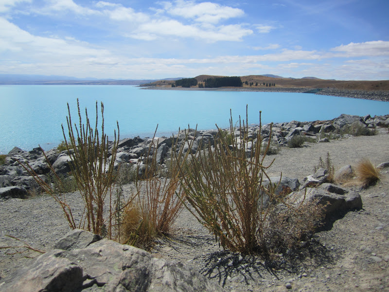
Blue Holes, where the Blue River and the Makarora River join up.  The two rivers have carved deep holes that are astonishingly blue. It was an easy walk on a paved path, so Wiley got to enjoy it, too.

Along the banks of the river are these stacked up stones.  I have no idea of their significance (if any), but it made me think how sacred this area must have been for the Maori people.

 Our lunch stop this day was on top of a hill with a view of even higher mountains in the distance.  We had a chance to admire some of the flowers and trees up close.
 There are many, many ferns, including tree ferns that get quite tall.  I like these that grew in big, round clumps.
 Flax is also very common.  The Maori made cloth and twine from its fibers.
 Lots of different kinds of flowers, too.
 I'm not sure whether this is a tree, a bush, or just a tall plant, but it's strange and wonderful looking.
We didn't see these Nihau Palm trees until we got further northwest, but since I'm talking about the vegetation now, I thought I'd include them here.

 These lilies were growing wild everywhere, but I also saw them planted in gardens, so they may have been escapees.
These orange blossoms grew in masses everywhere.  They're my new all-time favorite flower!

 Our next stop was Hokatika.  This little town was the center of the gold rush in the mid-1860's.  It's also the pounami (greenstone or jade) capitol of New Zealand.  Pounami has spiritual significance to the Maori, who used it for weapons and jewelry.

 The local shops are full of beautiful examples of the weapons and decorations (these were made by modern Maoria).

I don't know who would have bought this modern interpretation of a Maori feather cloak, but you'd sure stand out in a crowd if you wore it!


I walked around town a little and found this old building, which I thought was very interesting looking.  It's for sale for $450,000 if anyone would like to move here!

Now the road was getting much steeper with lots of hairpin curves, but the Mercedes camper handled it very well.  The roadcuts were often covered with ferns and the feeling is very tropical, like a rainforest.

After our drive through the Haast Pass, we got our first view of the Tasman Sea

Next stop:  Punakaki (Pancake Rocks).  This was another free area (there were lots of them on the South Island).  There was a great paved path, so Wiley was able to do it, too.

 The rock formations were really cool.  If you click on the picture on the left, you can see the detail of how the rocks are stacked. 
 Scientists know that the rocks are limestone and were under the sea for centuries, but they still cannot explain why they are stacked like they are.  If you click on the picture to the right, you can see the sea spray blowing out of the blow hole.  Whenever a big wave hits the shore, the spray come out the top.  The sea was not very rough when we were there; sometimes there's a very impressive plume out of the blowhole.

 We hadn't seen much wildlife up to this point, but we were greeted in the parking lot by two of these fearless birds.  They walked right up to us, pecking around the tires of each new vehicle that pulled into the parking area.  We later learned that they're a native New Zealand bird called a Weka.

We're off to a lovely seaside restaurant for lunch now, so I'll end here and continue the saga of our great New Zealand adventure in a day or two.  E noho rā
2/15/12 (Wednesday):  Happy birthday to me!  New Zealand is a wonderful present to myself.  We're having an incredible time.  I hardly know where to begin.  I guess we left off in Geraldine on Feb 12, where we were headed for Mt. Cook.  Here's a map of our journey from Picton to Cheviot (first night) to Geraldine (second night) to Lake Tekapo.

 We quickly got into a rhythm of waking, having a quick breakfast, unplugging and hitting the road by about 8 AM.  The camper is totally self contained, so we'd enjoy driving for a couple of hours and then pulling over somewhere beautiful and having a leisurely lunch.  Some days I made sandwiches, or I'd even cook hamburgers.  We bought food locally.  Meals taste great when you're surrounded by mountains, rushing rivers, glaciers and lakes!


 Our first stop on the second day out was Lake Tekapo.  This is a deep lake fed by glacial waters, so it's very cold.  The color is an indescribable blue.  It's surrounded by very high mountains, whose peaks are hidden in the clouds.  The Church of the Good Shepherd was founded in 1935 by residents of the Mackenzie District, who had previously held services at local stations (ranches).  They donated land and materials and built this lovely small church overlooking Lake Tekapo.  The view of Mt. Cook through the window over the simple alter is breathtaking.  They were about to start services when we arrived (that's the minister in the doorway).  There are about 12 pews inside and a simple table for an altar.  It's quite lovely.


 Nearby is this statue of a sheep dog commemorating the invaluable contribution of their work.  Sheepherding would have been impossible without the assistance of these hard working animals.


 The shores of the lake were rocky and arid looking with patches of gorgeous wildflowers.  We were surprised that there were still some lupine in bloom -- one of our favorite flowers.


Next we drove to Lake Pukaki (see map).  Again, the waters were incredible clear and blue.  There were even more rocks and less vegetation here, but there was a great view of Mount Cook in the far distance.

The camera was zoomed all the way out here, but that really is what the colors looked like (totally undoctored)!  While I was admiring the view, I noticed a young man (25 ish) who was repairing his bike tire.  He was loaded with camping gear and looking tired and frustrated.  I started a conversation, and found that he was a primary school teacher from Holland.  He had a screw completely through his tire and was unable to repair it.  We offered him a ride to the nearest town (Twizel) about 8 miles away and he gratefully accepted.  Turned out there were no bike shops in Twizel, so we invited him to join us the rest of the way to Wanaka.  We found a bike shop there and I bought some groceries and he stayed in his backpacker tent at our campsite and joined us for dinner.  He was a very engaging young man.  He'd been traveling in Australia for many months and was very thankful for a hot meal and a chance to email his Mum.  He didn't even have a cell phone with him -- just a young guy on an adventure!

From Lake Pukaki we headed southwest toward Wanaka, but it's late and Wiley's already asleep, so we'll save the remainder of the trip for another time.  E noho rā.
2/11/12 (Saturday):  My father-in-law, Wiley, would have loved New Zealand.  I forget whether he said he'd every been.  It's really beautiful and green and the people are so friendly.  They're very outdoorsy, too.  We've seen lots of people of all ages with backpacks and hiking boots.  The country is very accommodating of hikers, too, with very nice camping huts spaced along the tracks and lots of parking spaces near the trailheads.  If he had created a country himself, Wiley couldn't have planned one better than this! His funeral was today, and we're sad that we couldn't be there with family.


Before I get too far ahead of myself, I'll share a few pictures from our visit to the Te Papa Museum in Wellington.  Heather took me and Wiley while Mark was a work and the boys were in school.  The Mauri culture is fascinating and the museum is a real showcase.  If you're interested in learning a little more about these fascinating people, check out this link:   Maori of New Zealand


The day after our visit to the Te Papa Museum, Mark drove us to the ferry and we began our trip to the South Island.  We took the Interisland ferry Kaiteki across the Cook Straits from Wellington on the North Island of New Zealand to Picton on the South Island.  The 3-hour journey has been called one of the most beautiful sailings in the world.

It was a gray, drizzly day at first, but that just made for more dramatic pictures.  The ferry was lovely -- it held up to 1600 people (and lots of vehicles, too).  There were several cafes, lounges, play areas for kids and even Disney movies for those who didn't want to watch the scenery.

I was absolutely amazed as we began to enter the waters around the South Island to see how remote some of the homes were.  There were no visible roads or air strips, and yet here were these homes nestled at the foot of the mountains!

There even seemed to be a few seafood enterprises.  Not sure what they're raising or catching, but it's sure remotely located!


We landed in Picton and picked up our luggage.  We were met by the folks from Blue Horizon who took us to their facility to pick up our rental camper.  We got a thorough walk through to learn how everything worked.  It's a really nice camper.  Somehow they made it bigger inside than it is outside!  I was so worried about driving on the left side of the road and navigating unfamiliar territory in a strange vehicle, but they helped me feel more confident with their thorough instruction.  I also rented a GPS from them, which has helped tremendously.

So far, I haven't had any trouble at all with the driving.  We got a late start from Picton due to all the time spent learning about the camper.  We stopped and picked up some groceries and then headed out (in the rain).  We wanted to make it all the way to Cheviot, so the only stop we planned was near Kaikoura.  (See map).  The drive took us along the South Pacific coast with stunning views of turquoise water and crashing waves.  I soon got the feeling for driving on the left side of the road and feeling more calm and competent.

Just south of Kaikoura at Point Ohau there's a colony of fur seals.  We made our second stop here.  We stood on a cliff directly overlooking the colony, which was hauled up on the rocks.  The waves were crashing right over the seals!  There were babies, too.


While Wiley enjoyed the view, I took a 10-minute hike back to a waterfall.  When Mark and his family were there earlier this year, they saw baby seals playing the in pool under the waterfall.  I didn't see that, but the waterfall was gorgeous.


Today we're in Geraldine, headed west toward Mt. Cook.  We can see the tall mountains in the distance.  There are fields full of sheep everywhere.  Everything looks just different enough that we know we're in another country.  The towns are spaced widely apart and are pretty small.  The grocery stores are well stocked, but few and far between.  They carry many American brands, but the names have been changed slightly and the packaging is a different size.  I needed Zip Loc bags, and the sizes are so weird -- the sandwich bags are too big for bread slices and instead of gallon bags they have these huge 3 liter bags.  We stocked the camper when we arrived in Picton from the ferry.  We just got some basics, like coffee, milk, potatoes, cereal (Wheat-a-Bics!), peanut butter and jelly, eggs and lunchmeat.  We plan to stop for local specialties along the way.  Tonight it's steak and onion pies.  I'll nuke some potatoes to go with. 

There are sheep everywhere here!  We haven't seen much wildlife other than sheep and Magpies (black and white birds).  We're getting into wilder country now, so maybe we'll spot something interesting.  Mark is going to take us to a wildlife preserve when we get back.

Internet access is going to be very spotty this week, so I may not get to blog again until next week.  The campground we're at now has it for a fee, but I only get it until tomorrow morning.  We have a long drive ahead of us tomorrow, so I'm going to say E noho rā (goodbye) for now.

Joyce and Wiley

Joyce and Wiley
Our Home on Wheels

About Me

My photo
We took early retirement from careers as Executive Assistant (Joyce) and Lawn Care company owner (Wiley). We have been full-time RV'rs since March, 2006. We've taken our RV to Maine, Michigan, California, North Carolina and everything in between. We live in Florida in the winters and travel in the summers. It's a tough life, but someone has to live it!