Blue Penguin
2/21/12 (Tuesday):  We're enjoying spending some quiet days with family now that our adventure on the South Island is done.  Mark and Heather have a beautiful home just a few blocks from Worser Bay.  Mark and Wiley have been fishing several times (and actually caught some fish).  Heather is teaching me how to knit socks, which I've wanted to do for a long time.  I've taken the dog for some walks on the beach where we explore the tide pools.  We even saw a blue penguin right at the pier!

Pavlova


We've driven to Breaker Bay, also nearby, a couple of times and had lunch in the little cafe.  Restaurant food is very expensive here, though, so we're mostly enjoying Heather's good cooking.  (And I've cooked some of the fish the boys caught.)  Heather even made us a Pavlova, which is a Russian cake that's very popular in New Zealand (go figure!).  I'm bringing back the recipe, Mag.


 Yesterday, Mark took us into Wellington to the part of Weta (where he works) that allows tourists.  He actually works for Weta Digital, and the Weta Cave that we visited puts more emphasis on Weta Workshop, where they craft the props and costumes.  He has a very cool job!

Fishing on Seatoun Pier

The guys have gone fishing several times right from the nearby pier.  They caught enough fish that I did a fish fry for them one night.  Mark and Hudson are like me and don't care for fish, so there was plenty for Wiley, Heather and Austin.

Last Friday, Mark drove us to a wildlife sanctuary on Mt. Bruce, about 2 hours from home.  I just realized that I haven't showed many pictures of the little villages in New Zealand.  There are only a couple of real cities in NZ (Aukland and Wellington are the only ones we've visited).  The villages that we've been through on both islands remind me of Old West towns in the U.S.  The black and white pole with the red circle on top is a pedestrian crossing.  They call them "zebra crossings" and pedestrians in them have the right of way.
I love the railroad crossing signs!
But I digress...  The Bruce Mountain Wildlife Center was great!  They had a great walk through a forest with a creek (this is a redwood grove).
Tui


This bird, a tui, has a terrific song that just surrounded you as you walked.  Some of the rare birds were in large landscaped enclosures, but many, like this tui, were free.
Pukekos


These Pukekos look a lot like our purple gallinules in Florida, but they're much larger.
Kokako


 This Kokako is supposed to have a haunting cry.  This particular one actually does the wolf whistle over and over.  You could hear him throughout the grounds.  When I wolf whistled back, he got very interested and responded to me every time.  Poor thing must have been very lonely and bored!


The little creek that wound through the park was very jungle-y and pretty.  It made you feel like taking off your shoes and socks and going wading.


Giant Freshwater Eels

I lost the desire to wade when we came upon these giant eels.  They were hanging around the part of the creek where they get fed on a regular schedule.  Ick!
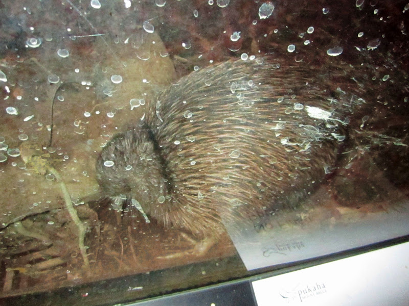


Kiwi

The big draw of this wildlife preserve is the kiwis.  They are nocturnal birds, very shy and endangered, and therefore very difficult to see in the wild.  Here they're kept in an enclosure where they turn on lights all night and keep it dark, with red lights, during the day.  It's very difficult to get pictures of them.  I felt super bad because I thought I'd turned my flash off, but it was on.  It didn't seem to bother the bird, which kept on feeding, but that mistake could have had awful consequences.

 This particular photo was a mistake, but I thought it was kind of amusing.  I was trying to take a picture of the grocery store so I could show you how each village has its own little shops.  Now you can see how I operate -- I always have the camera with me and I'm prone to drive other drivers (and passengers) crazy when I pull off the road and shoot pictures!  (I was in the passenger seat on the left side of the car and Mark was driving here, so it's not quite as dangerous as it looks!)

This is the New World Supermarket that I was trying to take a picture of from the car.  They're very similar to supermarkets in the U.S., including having a lot of familiar brands. 

Not every village has a supermarket, though.  There are a lot of small towns that have a small, old fashioned grocery store like this one in the next town we visited, Castle Point.

Castlepoint is a tiny seaside town where there was a lighthouse we wanted to take a picture of.  The Castlepoint Light was named by Captain Cook because the promontory on which it sits resembles a medieval fortress.

They were pulling boats up out of the water with these odd tractor devices when we arrived.  The beace is very hard sand and there was nowhere to put a boat ramp, so these unique vehicles were used.

Mark and I ignored this danger sign about rogue waves and climbed to the top of the rocks to get a better view.

From the top you can see that there's a rocky ridge separating the Pacific from a lagoon area.  The lagoon is filled at high tide when waves crash over the low point in the rocks.  Or when a rogue wave comes along, which is the reason for the danger sign.

It was altogether a lovely day.  Today Mark is back to work, the boys are back to school, and we're having a lazy morning.  This afternoon Heather has a friend visiting.  We may walk down to the beach to get a picture of the arch I saw when I didn't have my camera.  Or we may just continue to be lazy and knit.  Both sound like pleasant choices.  We head back to the States on Saturday the 25th.  Not sure whether I've got another blog in me, but I can still be reached via email or Facebook.  Bye for now.
2/19/12 (Sunday):  We're having a quiet morning, waiting for the rest of the household to awaken.  Wiley and I are usually up before the rest of the gang (maybe still on U.S. time a little?).  I'm learning how to knit socks, so I tried my hand at a couple of rows while Heather was still in bed, but I think I messed up, so I quit until she can help me.  I'll take advantage of the quiet and try to get caught up on my blogging.  We left you last time in Nelson, where we spent the last night of our South Island trip.  The final leg of the journey was short, because we had to return the camper and catch the 1:30 ferry.  But it was another beautiful leg of the journey, along the Pelorus River, through the Rai Vallen and finally along Queen Charlotte Sound.  Here's a map

We left Nelson on my birthday, and I was looking for something special to mark the day.  So, when we came across the signs for the longest swingbridge in New Zealand, I just had to check it out.  I walked all the way across this bridge and even took my hands off the railings to take pictures of the waterfall.
The bridge crosses the Buller River.  It was a fantastic experience!

The Pelorus River is a river at the northern end of the South Island in the Marlborough Region. It flows from the Richmond Range into Pelorus Sound.  This area is fantastic for camping and is renowned for its magnificent river swimming where the Pelorus River runs through a gorge.

 We enjoyed traveling on some more winding mountain roads with striking views around every curve and a number of one-lane bridges to cross.  These bridges are especially common on the South Island.  There are signs ahead of time that tell you who has the right-of-way and you sometimes have to wait a few minutes while other vehicles finish crossing.  These bridges make a lot of sense to me -- why pay to build a two lane bridge in an area where there's little traffic and people are going slowly anyhow?

Settlements are quite scattered and remote.  This sheep station is typical.

We especially enjoyed the end of our South Island adventure along the Queen Charlotte Sound.  I had to pay close attention to the driving, but the scenery was just breathtaking.  We enjoyed watching some folks gathering mussels at low tide near these boathouses.  

We were thankful there were places to pull over like this one.  Because we had the camper, we didn't need to worry about finding a place to eat, use the bathroom or just take a break from driving.

Finally, though, we had to say "goodbye" to the South Island, turn in our camper and board the ferry for the 3-hour trip back to the North Island and Mark and family.  It was a much sunnier day for the trip back and we enjoyed seeing the tops of the mountains that had previously been hidden in the clouds.

Next blog:  Continuing adventures on the North Island!  Stay tuned, and E noho rā for now!

2/18/12 (Saturday):  I believe I left off the last blog rather abruptly in Hokatika because we were getting ready to go out for lunch.  And I actually had the journey reversed; we traveled north on the West Coast of the South Island, so we actually went from Fox Glacier to Hokatika, not the other way around.  So let's finish the day (our 4th day, 2/13) from Fox Glacier to Hokatika (see map).  Since it's all out of order anyhow, here's a shot of Wiley at Punakaki that I didn't include before.  Do you think he's having fun yet?!

Wiley at Punakaki

 This is a view of Fox Glacier from the little town of Fox Glacier.  In order to get closer, you have to take a long hike or an expensive air tour.  We were happy just to see it from below.
 Access to Franz Josef glacier was similarly limited.

We spent our 4th night at Fox Glacier Holiday Park.  All of the holiday parks (as campgrounds are known here) were very nice, with kitchen and laundry facilities, but this one was truly a resort.  Campers had access to bathing in hot springs (for a pretty steep fee).  I chose to utilize the hot tub, which gave me a private 1/2 hour in a lovely Jacuzzi with rain forest all around.  The birds were twittering all around, and I started imitating one of them that whistled a pretty little tune.  To my surprise, it flew right up to within 12 inches of my face and started fanning its tail and dancing around for me.  It was a native bird called Piwakawaka (fantail).  I know that some of you aren't as "into" nature as me, but this was really a peak experience for me!

Lake Wanaka
To finish up with some random shots that I left out of my previous (backwards) blog, here are a couple of the gorgeous glacial lakes where we took breaks.

Lake Hawea


Okay.  Now that I have you totally confused about our route (welcome to the world of the geographically/spatially challenged), we'll continue our trip.


From Fox Glacier, we continued north on the West Coast toward Nelson.  This part of the country was settled during the mid 1800's during the great gold rush.  It's beautiful country, but very rugged.  The towns are now small and spaced far apart. 

For my 67th birthday, I just had to do something adventurous (because flying to the other side of the world and driving a camper on the "wrong" side of the road didn't seem all that adventurous), so when I saw this swingbridge, I knew I had to do it!  It's New Zealand's highest swingbridge and crosses the beautiful Buller River.  The Maori called it the Kawatiri, which means deep and swift.


There was a zip line you could take to come back that looked like a lot of fun, but it was too expensive for me, so I settled for a leisurely walk.  I even took my hands off the rails for a few minutes to get this shot of the waterfall.


Our next and final destination was Nelson.  Part of the journey was through the Pelorus River Gorge -- breathtaking!  We saw some kayakers, which made us wish we had our kayaks and a couple more weeks to explore.

We spent our final night in Nelson, which was less interesting than I expected.  It's famous for its golden beaches, but it looked much like any Florida beach I've been to except for the distant mountains.


But the campground in Nelson was one of the best yet -- we even got adopted by one of the resident ducks, who liked to hang out by our camper door!

 Wiley took advantage of the free afternoon to take a nap while I did some laundry.  Altogether a satisfying day, even though the scenery wasn't as spectacular as the previous part of the trip.

I have one last blog to do about our South Island advanture, but I think I'll safe it for another day.  From Nelson, we headed back to Picton to turn in the camper and board the ferry for a pretty spectacular trip back to the North Island.  So stay tuned, and E noho rā for now.
2/17/12 (Friday):  Wow -- our time in New Zealand is passing so quickly!  We're back in Seatoun with Mark's family now.  When I last blogged, we were on our way to Wanaka.  So let's get caught up!

From Lake Pukaki, we went to Twizel with our new biking friend.  There were no bike shops in Twizel, so he continued to Wanaka with us, as mentioned in my last blog.  We continued to our next stop, Fox Glacier, the next morning and he left on his new bike tires to Queenstown.  See map.

The terrain was getting more and more mountainous and lush as we headed west.  We crossed over the Haast Pass and through Mount Aspiring National Park.  Our first stop along the way was the Blue Holes, where the Blue River and the Makarora River join up.  The two rivers have carved deep holes that are astonishingly blue. It was an easy walk on a paved path, so Wiley got to enjoy it, too.

Along the banks of the river are these stacked up stones.  I have no idea of their significance (if any), but it made me think how sacred this area must have been for the Maori people.

 Our lunch stop this day was on top of a hill with a view of even higher mountains in the distance.  We had a chance to admire some of the flowers and trees up close.
 There are many, many ferns, including tree ferns that get quite tall.  I like these that grew in big, round clumps.
 Flax is also very common.  The Maori made cloth and twine from its fibers.
 Lots of different kinds of flowers, too.
 I'm not sure whether this is a tree, a bush, or just a tall plant, but it's strange and wonderful looking.
We didn't see these Nihau Palm trees until we got further northwest, but since I'm talking about the vegetation now, I thought I'd include them here.

 These lilies were growing wild everywhere, but I also saw them planted in gardens, so they may have been escapees.
These orange blossoms grew in masses everywhere.  They're my new all-time favorite flower!

 Our next stop was Hokatika.  This little town was the center of the gold rush in the mid-1860's.  It's also the pounami (greenstone or jade) capitol of New Zealand.  Pounami has spiritual significance to the Maori, who used it for weapons and jewelry.

 The local shops are full of beautiful examples of the weapons and decorations (these were made by modern Maoria).

I don't know who would have bought this modern interpretation of a Maori feather cloak, but you'd sure stand out in a crowd if you wore it!


I walked around town a little and found this old building, which I thought was very interesting looking.  It's for sale for $450,000 if anyone would like to move here!

Now the road was getting much steeper with lots of hairpin curves, but the Mercedes camper handled it very well.  The roadcuts were often covered with ferns and the feeling is very tropical, like a rainforest.

After our drive through the Haast Pass, we got our first view of the Tasman Sea

Next stop:  Punakaki (Pancake Rocks).  This was another free area (there were lots of them on the South Island).  There was a great paved path, so Wiley was able to do it, too.

 The rock formations were really cool.  If you click on the picture on the left, you can see the detail of how the rocks are stacked. 
 Scientists know that the rocks are limestone and were under the sea for centuries, but they still cannot explain why they are stacked like they are.  If you click on the picture to the right, you can see the sea spray blowing out of the blow hole.  Whenever a big wave hits the shore, the spray come out the top.  The sea was not very rough when we were there; sometimes there's a very impressive plume out of the blowhole.

 We hadn't seen much wildlife up to this point, but we were greeted in the parking lot by two of these fearless birds.  They walked right up to us, pecking around the tires of each new vehicle that pulled into the parking area.  We later learned that they're a native New Zealand bird called a Weka.

We're off to a lovely seaside restaurant for lunch now, so I'll end here and continue the saga of our great New Zealand adventure in a day or two.  E noho rā

Joyce and Wiley

Joyce and Wiley
Our Home on Wheels

Blog Archive

About Me

My photo
We took early retirement from careers as Executive Assistant (Joyce) and Lawn Care company owner (Wiley). We have been full-time RV'rs since March, 2006. We've taken our RV to Maine, Michigan, California, North Carolina and everything in between. We live in Florida in the winters and travel in the summers. It's a tough life, but someone has to live it!